
Drone Topo Services
Professional, experienced and dependable Raleigh-based surveying.
Looking for better accuracy in less time?
Surveying with drone topography offers enormous potential when it comes to the accuracy of your project. At DiGiagomo Land Surveying, PLLC we carry out topographic surveys with drones to collect highly accurate measurements in a short amount of time. This leads to a substantial decrease in the cost of site survey and increases the overall efficiency of the project.
What is Drone Topography?
A topographic survey provides a comprehensive map of the land on which construction is to begin, in order to determine its feasibility. Drone topography makes use of a drone or unmanned aerial vehicle to capture aerial data. This is an effective and accurate way to confirm the existing elevations on site, before grading work begins
During a drone survey the land in question is photographed by downward facing sensors from multiple angles. While mapping, each photograph is tagged with coordinates. These maps include cad and photo deliverables. Online cloud platforms allow further analysis of the site.
Why Use Drone Topography?
- Reduces field time and the cost of site surveying.
- Provides precise and comprehensive data.
- Keeps track of earthwork quantities as the project progresses.
- Maps areas that would have otherwise been inaccessible, such as elevations , slopes, and harsh terrains.
- Always allows access to updated maps
How Accurate is Drone Topography?
While drone topography is considered to be highly accurate, several factors may influence the accuracy of its mapping. The type of drone used and its performance is essential to accurate results. Similarly the camera resolution and the method used to interpret the aerial images affects the end result. DiGiacomo ensures the use of quality drones for meticulous data collection. Our professionals are trained to use drone topography to deliver error-free results, and that too in a fraction of the time of traditional methods!
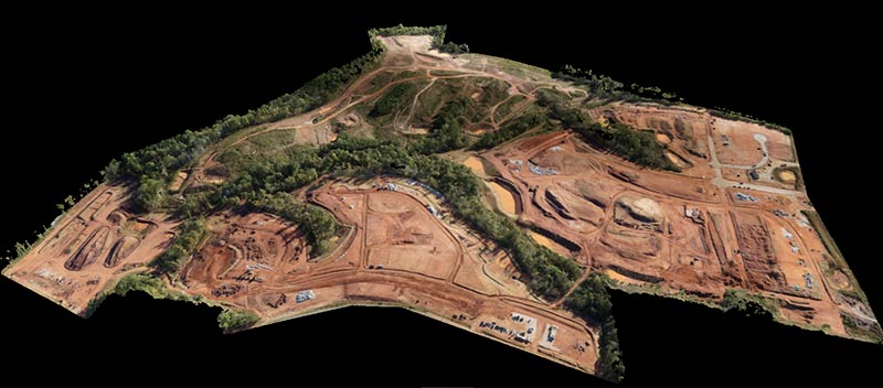
See an example below:
Let’s Partner On Your Next Project!
If you’re looking for a more efficient way to carry out land surveying, it might be time to consider drone topography! We can help you acquire accurate data and ensure your construction project’s success.